
In the previous post we identified 9 biblical routes. This post continues with the nine remaining routes.
10) Deuteronomy 11:30 (MT): “דֶּרֶךְ מְבוֹא הַשֶּׁמֶשׁ” = Derech Mevo HaShemesh
-
Explanation: Identifying this route depends on a few unresolved variables. The first question is a Talmudic debate over the location of the ceremony of setting the 12 stones after crossing the Jordan and the location of the blessing and curse ceremony. The Talmud in Sotah 33b records a disagreement on whether the above ceremonies occurred near the Jordan River crossing, at Gilgal, or they occurred many miles northwest of the crossing, near Shechem, the actual location of Gerizim and Ebal. A related dispute is the route that is referenced in the Torah, "after i.e. far from, the way of mevo hashemesh." Does Mevo Hashemesh mean the rising sun or the setting sun? If the route refers to the setting sun (the west), then the ceremony happened in the east near the Jordan River at Gilgal. If, however, the route refers to the way of the rising sun (in the east), then the ceremony was west of that, near Shechem. In short, the route is either far west of the Jordan or far east of Shechem. This question is further complicated by the identity of Gilgal. The Gilgal site has never been identified with any definitive Bronze Age remains. Multiple standing stone 'circle's (more foot shaped) cultic sites have been found in the rift valley area, and one of them may refer to the biblical Gilgal. Some researchers have theorized that Gilgal is not a specific place name but a generic term for these standing stone cultic sites. Another possible Gilgal identification is a village near Shechem by the name of Kfar Jiljuliya. Regardless of the location of Gilgal, the route of Mevo Hashemesh itself can be understood in 2 ways. The simple meaning of road of the rising or setting sun, would refer to a 'directional' road. Towards the rising sun, eastbound, or towards the setting sun, westbound. Locating those roads would depend on the Talmudic dispute. A westbound road into Israel could be any road such as Jericho-Jerusalem, or perhaps Wadi Faria towards the hill country and Shechem. An eastbound road from the Jordan area would be a road though the Moabite territory. But its also quite possible that the reference is not directional, but locational. The road of the setting sun can mean the western boundary road, i.e. via maris. The road of the rising sun, can mean the eastern boundary road, along the bik'a valley, somewhere around route 90.
-
Route Scenarios:
- Directional: Westbound ("Setting Sun"): Route Example: Jericho → Wadi Faria (32.150°N, 35.350°E) → Shechem; Ceremony Location: Gilgal near Jericho, east of this route.
- Directional: Eastbound ("Rising Sun"): Route Example: Roads through Moabite territory (e.g., Wadi al-Hasa or Wadi Mujib) into Transjordan; Ceremony Location: Shechem (Gerizim/Ebal), west of this route.
- Locational: Boundary Roads: Western Boundary: Via Maris (coastal highway); Eastern Boundary: Jordan Rift Valley (Bik'at HaYarden).
-
Pin Locations: Gilgal (Jericho) (31.870°N, 35.444°E), Gilgal (Shechem) (32.166°N, 35.383°E), Shechem (Nablus) (32.221°N, 35.255°E), Mount Gerizim (31.913°N, 35.183°E), Mount Ebal (31.929°N, 35.183°E), Wadi Faria (32.150°N, 35.350°E), Moabite Hills/Wadis (31.500°N, 35.783°E).
11) דרך הערבה = Derech HaArabah (six mentions): A Case of Contextual Geography
While ‘Derech + place-name’ typically denotes a fixed route (e.g., Derech Shur), דֶּרֶךְ הָעֲרָבָה (Derech Ha’arabah) is different. The modern use of the word Arabah is the southern Jordan rift valley, between the Dead Sea and the Gulf of Aqaba. However, biblically, the word Arabah does not refer to a place-name, it is not a proper noun. Rather, it is a geological descriptor. Arabah means a deep and arid valley or gorge. It is only when paired with a modifier that it becomes a compound place-name. An example is Joshua 8:13-14:
וַיָּשִׂ֨ימוּ הָעָ֜ם אֶת־כׇּל־הַֽמַּחֲנֶ֗ה אֲשֶׁר֙ מִצְּפ֣וֹן לָעִ֔יר וְאֶת־עֲקֵב֖וֹ מִיָּ֣ם לָעִ֑יר וַיֵּ֧לֶךְ יְהוֹשֻׁ֛עַ בַּלַּ֥יְלָה הַה֖וּא בְּת֥וֹךְ הָעֵֽמֶק׃
וַיְהִ֞י כִּרְא֣וֹת מֶלֶךְ־הָעַ֗י וַֽיְמַהֲר֡וּ וַיַּשְׁכִּ֡ימוּ וַיֵּצְא֣וּ אַנְשֵֽׁי־הָעִ֣יר לִקְרַֽאת־יִ֠שְׂרָאֵ֠ל לַֽמִּלְחָמָ֞ה ה֧וּא וְכׇל־עַמּ֛וֹ לַמּוֹעֵ֖ד לִפְנֵ֣י הָעֲרָבָ֑ה וְהוּא֙ לֹ֣א יָדַ֔ע כִּֽי־אֹרֵ֥ב ל֖וֹ מֵאַחֲרֵ֥י הָעִֽיר׃
Here, Arabah clearly refers to a gorge north of the city of Ay and not the Jordan rift valley. When paired with a modifier, such as Arbot Moab (Numbers 22:1), then it becomes a place name. Similarly, Bik’ah is a valley, when referring to a specific valley it is compounded with a modifier, such as Bik’at Jericho (Deuteronomy 34:3). Therefore, Derech Ha’arabah is not included in our opening rule. Derech when paired with a geological descriptor is a fluid contextual reference and does not refer to a known named route network. Examples:
Deuteronomy 2:8
וַֽנַּעֲבֹ֞ר מֵאֵ֧ת אַחֵ֣ינוּ בְנֵי־עֵשָׂ֗ו הַיֹּֽשְׁבִים֙ בְּשֵׂעִ֔יר מִדֶּ֨רֶךְ֙ הָֽעֲרָבָ֔ה מֵאֵילַ֖ת וּמֵעֶצְיֹ֣ן גָּ֑בֶר וַנֵּ֨פֶן֙ וַֽנַּעֲבֹ֔ר דֶּ֖רֶךְ מִדְבַּ֥ר מֹואָֽב׃
This refers to their path through the lower Jordan rift valley, from the Dead Sea to the Gulf of Aqaba.
II Samuel 4:7
וַיָּבֹ֣אוּ הַבַּ֗יִת וְהֽוּא־שֹׁכֵ֤ב עַל־מִטָּתֹו֙ בַּחֲדַ֣ר מִשְׁכָּבֹ֔ו וַיַּכֻּ֨הוּ֙ וַיְמִתֻ֔הוּ וַיָּסִ֖ירוּ אֶת־רֹאשֹׁ֑ו וַיִּקְחוּ֙ אֶת־רֹאשֹׁ֔ו וַיֵּֽלְכ֛וּ דֶּ֥רֶךְ הָעֲרָבָ֖ה כׇּל־הַלָּֽיְלָה׃
This likely refers to an east-west route towards the Jordan rift valley, near Jericho, north of the Dead Sea.
II Kings 25:4, Jeremiah 39:4, Jeremiah 52:7
וַתִּבָּקַ֣ע הָעִ֗יר וְכׇל־אַנְשֵׁ֨י הַמִּלְחָמָ֤ה ׀ הַלַּ֨יְלָה֙ דֶּ֜רֶךְ שַׁ֣עַר ׀ בֵּ֣ין הַחֹמֹתַ֗יִם אֲשֶׁר֙ עַל־גַּ֣ן הַמֶּ֔לֶךְ וְכַשְׂדִּ֥ים עַל־הָעִ֖יר סָבִ֑יב וַיֵּ֖לֶךְ דֶּ֥רֶךְ הָעֲרָבָֽה׃
These refer to the flight from Jerusalem, towards Jericho in the east. The northern rift valley.
12) Joshua 10:10 (MT): “דֶּרֶךְ מַעֲלֵה בֵית-חוֹרוֹן” = Derech Ma'ale Beit-Horon
-
Explanation: An east-west route from the Judean hills down a narrow mountain pass to the Shepheilah plain via the Beth-Horon ascent, used by Joshua to pursue the Amorite kings after the battle of Gibeon (Joshua 10:10). It connected the Way of the Patriarchs to paths that could eventually lead to the Via Maris. Today, this route is followed by Highway 443, connecting Jerusalem to the coastal plain via the Beth-Horon ascent.
-
Pin Locations: Gibeon (31.847°N, 35.185°E), Beth-Horon (31.879°N, 35.115°E), Jerusalem (31.768°N, 35.213°E).
13) Joshua 15:7, 18:17: “מַעֲלֵה אֲדֻמִּים” = Ma'ale Adumim
-
Route Type: East–West
-
Function: Ascent from the Jordan Valley into the Judean highlands
-
Geography: Begins in the Bik'a (Jordan Valley), just north of the Dead Sea; West of the Red Hills of Jordan; Climbs through the ascent now mirrored by modern Route 1; Arrives in Jerusalem.
-
Modern Equivalent: Route 1 (Jericho–Jerusalem Road)
14) 1 Samuel 6:12 (MT): “דֶּרֶךְ בֵּית שֶׁמֶשׁ” = Derech Beth Shemesh
-
Explanation: Derech Beth Shemesh, meaning "the Way to Beth-Shemesh," is a biblically attested route named in 1 Samuel 6:12, where the Ark of the Covenant was returned from Philistine territory to Israel. The text describes how the Philistines, after capturing the Ark, placed it on a cart pulled by two cows in Ekron, and the cows went "straight up toward Beth Shemesh, keeping on the road [Derech Beit Shemesh], and lowing all the way; they did not turn to the right or to the left." This route connected the Philistine city of Ekron (Tel Miqne, 31.869°N, 34.849°E) to the Judean city of Beth-Shemesh (Tel Beit Shemesh, 31.747°N, 34.987°E), a distance of approximately 20–22 kilometers (12–14 miles). The path followed the Sorek Valley (Nahal Sorek), a natural corridor between Philistine and Judean territory in the Shephelah, which facilitated trade and travel in ancient times. The historical Nahal Sorek railway, constructed in the late 19th century, later followed this same corridor, underscoring its significance as a travel route. Beth-Shemesh, located on the northern bank of the Sorek Valley and slightly north of the modern city of Beit Shemesh, was a frontier city for Judah, making it a strategic endpoint for the Ark’s return. While the route’s existence is clear from the biblical text, the exact path within the Sorek Valley remains speculative due to the lack of direct archaeological evidence for the specific road in the Iron Age I (1200–1000 BCE).
-
Source: Google My Maps
Interactive map of biblical routes, including Derech Beth Shemesh.
15) Judges 17:8: “דֶּרֶךְ הַר אֶפְרָיִם” = Derech Har Ephraim
-
Biblical Term: דֶּרֶךְ הַר אֶפְרָיִם (Judges 17:8)
-
Route Type: North–South, central highland ridge route
-
Function: Subsection of the Way of the Patriarchs, running through Benjaminite and Ephraimite territory
-
Biblical Context: The story of the Pilegesh in Gibeah.
-
Geography: Begins just north of Jerusalem; Runs through the tribal territory of Benjamin; Continues into the hills of Samaria; Includes cities like Bethel, Shiloh, and Shechem.
-
Modern Equivalent: Highway 60, particularly the segment north of Jerusalem through Ramallah, Shiloh, Nablus.
16) Isaiah 8:23 (MT): “דֶּרֶךְ הַיָּם” = Derech HaYam
-
Interpretive Options and Historical-Geographical Context:
- Definition and Context: The phrase “דֶּרֶךְ הַיָּם” (Derech HaYam, “Way of the Sea”) refers to a critical ancient route associated with Assyrian military campaigns in the 8th century BCE. Its identification hinges on the ambiguous term “יָּם” (yam, “sea”), which could denote either the Mediterranean or the Sea of Galilee (יָם כִּנֶּרֶת), or both.
- Interpretive Options:
- Coastal Via Maris (Sharon Plain): Path: Northern stretch of the Via Maris, running along the Mediterranean coast through the Sharon Plain (Dor to Haifa). Evidence: Assyrian annals (Tiglath-Pileser III) emphasize coastal conquests (e.g., Acco, Tyre). Critique: Less directly tied to Isaiah 9:1’s focus on Zebulun/Naphtali (inland Galilee).
- Inland Route (Northeastern Spur to Transjordan): Path: A branch of the Via Maris diverging northeast at Megiddo (32.585°N, 35.183°E), traversing the Jezreel Valley to the Sea of Galilee (32.813°N, 35.590°E), then connecting to the King’s Highway in Transjordan. Linguistic Flexibility: Mediterranean: If yam refers to the Mediterranean, the route’s coastal origin is acknowledged. Sea of Galilee: If yam refers to the inland sea, the route’s terminus near Galilee is emphasized. Dual-Sea Symbolism: The term may evoke both seas, framing the route as a connector between maritime and inland zones. Evidence: Assyria’s destruction of Hazor (33.016°N, 35.568°E) and annexation of Naphtali (2 Kings 15:29). Isaiah 9:1 explicitly links the route to Zebulun/Naphtali. Critique: No ancient source explicitly names this inland route “Way of the Sea.”
- Northern Extension into Lebanon: Path: Coastal route extending to Phoenician cities (Tyre, Sidon). Evidence: Assyrian control over Phoenicia (734–732 BCE). Critique: Less relevant to Isaiah’s focus on Israelite territories.
- Key Considerations: Assyrian Strategy: Tiglath-Pileser III’s campaigns (734–732 BCE) targeted both coastal and inland regions, though likely sequentially rather than via split forces. Textual Nuance: Isaiah’s phrasing merges geography and theology (e.g., “Galilee of the Nations” as both physical territory and symbol of foreign domination).
-
Geographical Pin Locations: Dor (32.618°N, 34.918°E), Acco (32.928°N, 35.076°E), Megiddo (32.585°N, 35.183°E), Hazor (33.016°N, 35.568°E), Sea of Galilee (32.813°N, 35.590°E), Beth Shean (32.497°N, 35.502°E), Damascus (33.513°N, 36.276°E).
-
Conclusion: The phrase “דֶּרֶךְ הַיָּם” most likely refers to the northeastern spur of the Via Maris, a route that: Originated near the Mediterranean coast (per Radak’s association with the Via Maris). Diverged inland toward the Sea of Galilee (per Rashi’s focus on Naphtali’s territory). This interpretation reconciles the linguistic ambiguity of yam by acknowledging its dual geographic referents while prioritizing the route’s historical role in Assyria’s conquest of Galilee (Isaiah 9:1).
17) Isaiah 15:5 (MT): “דֶּרֶךְ חוֹרֹנַיִם” = Derech Horonaim
-
Explanation: A local Moabite path in Transjordan, mentioned in a prophecy against Moab (Isaiah 15:5), likely linking settlements like Horonaim, also mentioned in Jeremiah 48, (possibly near modern Karak on Moab’s eastern border, or Nahal Zered-Wadi Al Hasa on Moab’s southern border) to the King’s Highway. According to Radak, Horonaim indicates twin cities or twin peak on either side of a pass.
-
Pin Locations: Horonaim (possibly near Karak, 31.181°N, 35.704°E), Karak (31.181°N, 35.704°E).
18) 2 Kings 3:8 & 3:20 (MT): “דֶּרֶךְ מִדְבַּר אֱדוֹם” and “מִדֶּרֶךְ אֱדוֹם” = Derech Midbar Edom
-
Explanation: A route through the wilderness of Edom, used by the kings of Judah, Israel, and Edom in a campaign against Moab (2 Kings 3:8, 3:20). The text relates that Jehoram of Israel approached Jehoshaphat of Judah for an alliance against Moab. The alliance was formed between Israel and Judah, along with the King of Edom. While strategizing on how to march on Moab the question was raised ‘Through which way should we go?’ It was decided to go ‘Derech Midbar Edom’. After a 3 day difficult journey, the alliance ran out of water for the soldiers and animals and could not find any water source. The effort seemed doomed to failure. Elisha the Prophet showed up and promised that every pit in the valley would become filled with water the next day. In this context, we need to understand the question ‘Through which way should we go?’
-
The simple explanation is that Judah controlled the south of the country and the access to Edom. Israel controlled the north of the country with access to Gilead. Moab can be approached either through going south southeast, through the Judean desert, towards the Arabah. That portion was already Midbar Edom. From there they could ascend to the Transjoranian plateau, either through one of the wadi mountain passes, or the longer but more accessible King’s Highway. Moab can also be approached from the north, travelling through Ephraim, into the Galilee, past the sea of Galilee and towards Bashan where they cross into the territory north of Moab to face off with Moab to their south.
-
In this framing of the question, the parties decided that Moab was far better defended from the accessible north and they chose to approach via Edom. The less defended, yet far more demanding terrain.
-
Route Identification: Derech Midbar Edom is the southeast path from Judah towards the Arabah. This road began around the city of Arad and went through the wilderness in a winding and sharp descent towards the southern tip of the Dead Sea.
In c. 1960, Yohanan Aharoni and Beno Rothenberg teamed up to discover this exact route from Judah to Edom. By locating Iron-age fortresses along desert paths, they determined the likely course of the ancient route. Beginning just south of Arad is a wadi called Nahal Amiaz. At the beginning of this path are 2 fortresses, Horvat Uza and Horvat Radum. All the way down, near the Arabah, is another fortress, known as Zohar fortress. The above pair charted a course beginning at the upper fortresses and ending near the lower fortress. See image below, follow the red line.
Map of Derech Midbar Edom, following Nahal Amiaz to Zohar Road (red line).
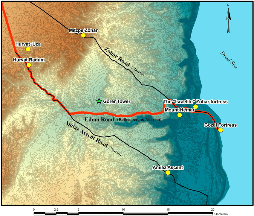
This route follows Nahal Amiaz until it reaches Nahal Heimar, continues mostly straight but a bit north to reach Zohar Road where it continues to descend.
In 2020, a team of researchers, among them Eli Cohen-Sasson, found an additional fortress in another north south wadi called Nahal Gorer, right at the junction of Nahal Gorer and Nahal Heimar. They suggest that 2 separate roads to Edom existed. The first one being the Zohar Road, and a second independent road following Nahal Amiaz. Following this path without turning off to meet the Zohar road would save significant time and effort. Nahal Gorer, with its watchtower was a connecting road should one choose to travel from one route to the other route. See the map below.
Map showing dual routes: Zohar Road and Nahal Amiaz, with Nahal Gorer junction.
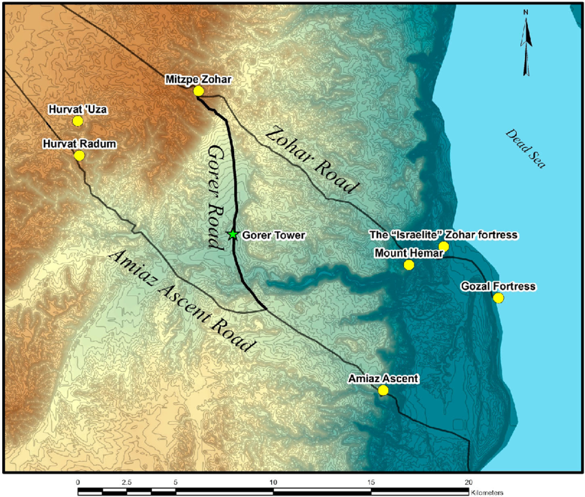
In this finding there is a new understanding of the question ‘Through which way shall we go?’ The upper road was associated with The Judean Desert, the lower, Amiaz Road terminated in the Edomite desert.
Today, the Israel National Trail meanders between these ancient routes.
Pin Locations: 1. Arad (Starting Point) 31.280°N, 35.125°E 2. Horvat Uza (Upper Fortress) 31.233°N, 35.200°E 3. Horvat Radum (Upper Fortress): 31.216°N, 35.216°E 4. Nahal Amiaz (Wadi Amiaz). 5. Nahal Heimar (Wadi Heimar Junction): 31.200°N, 35.250°E 6. Zohar Fortress (Terminus of Zohar Road): 31.250°N, 35.183°E 7. Nahal Gorer (Intersection with Watchtower): 30.900°N, 35.200°E 8. Southern Tip of the Dead Sea: 31.200°N, 35.400°E
Comments
Post a Comment