
Chapter 1: The Fertile Crescent: The Cradle of Civilization and Its Trade Routes
The Fertile Crescent, often referred to as the “Cradle of Civilization,” is a sweeping arc of fertile land that stretches from the Persian Gulf through Mesopotamia, across the Levant, and into the Nile Delta. This region, nourished by the Tigris, Euphrates, and Nile rivers, provided the ideal conditions for the development of early urban centers, agriculture, and trade networks that shaped the ancient world.
Geography and Topography of the Fertile Crescent
The landscape of the Fertile Crescent is defined by its contrasting features: the alluvial plains of Mesopotamia, the rugged mountain ranges of Anatolia and the Levant, and the expansive deserts of Syria and the Arabian Peninsula. Each of these geographic elements played a crucial role in determining the movement of people, goods, and armies.
- Mesopotamia: Dominated by the Tigris and Euphrates Rivers, this region provided fertile soil for agriculture but was also subject to seasonal flooding. The rivers acted as natural highways, enabling transport and commerce between cities such as Ur, Babylon, and Nineveh.
- The Levant: A narrow coastal corridor between the Mediterranean Sea and inland deserts, the Levant connected Mesopotamia with Egypt. Its varied terrain, from coastal plains to the rugged Judean and Lebanese highlands, shaped settlement patterns and travel routes.
- Egypt and the Nile Delta: The Nile, with its predictable flooding and rich silt deposits, supported one of the most stable civilizations in history. Egyptian trade extended into the Levant, Sinai, and beyond, linking Africa with the Middle East.
- The Syrian and Arabian Deserts: Though harsh and arid, these deserts were crossed by important caravan routes, particularly those connecting Mesopotamia with the Levant and the Arabian Peninsula.
This diverse terrain not only nurtured early agriculture but also channeled the flow of trade and conquest across the ancient world.
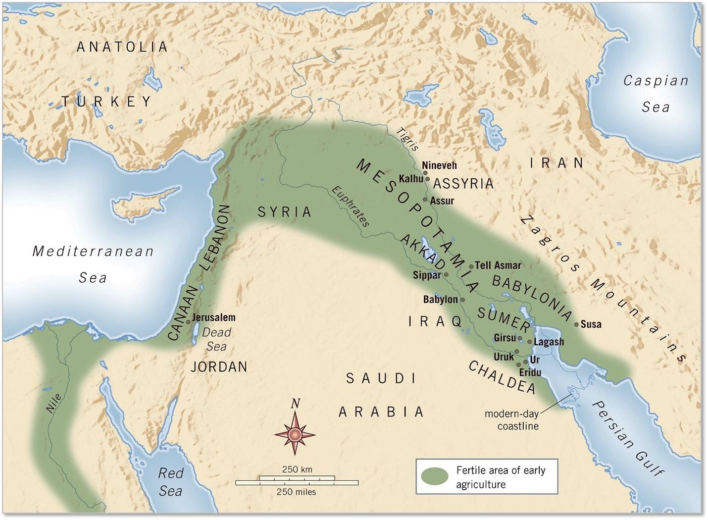
1. Map of the Fertile Crescent, showing the areas around the rivers in green.
Major Trade Routes of the Fertile Crescent
The movement of people and goods in the ancient world was heavily influenced by geography. Key routes developed that connected cities, facilitated commerce, and enabled the expansion of empires.
- The Euphrates and Tigris River Routes: These waterways served as primary transport corridors for goods such as grain, textiles, and metals, linking the cities of Sumer, Akkad, Assyria, and later Babylon.
- The King’s Highway: Running along the eastern side of the Jordan River, this route connected Damascus to the Red Sea, passing through Ammon, Moab, and Edom.
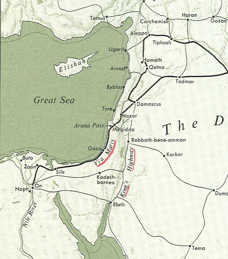
- The Via Maris: A coastal route linking Egypt to Mesopotamia, passing through Gaza, Jaffa, and the Jezreel Valley before reaching Syria.
- The Royal Road of Persia: Established by Darius I, this route connected Susa to Sardis, integrating Mesopotamia into the Persian Empire’s vast communication network.
- Desert Caravan Routes: Used by traders transporting incense, spices, and precious goods from Arabia into the Levant and beyond.
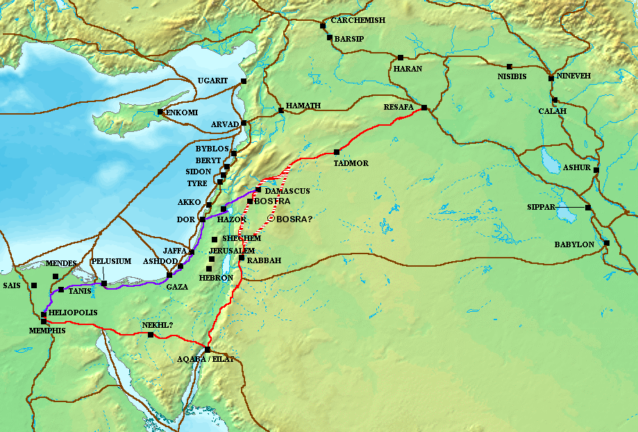
2. The Purple Line is the Via Maris. The Red Line is the Kings Highway. The brown line from Babylon to Jordan is likely the route mentioned in Chapter 6.
Conclusion
Understanding the topography and trade routes of the Fertile Crescent provides crucial insight into how geography shaped the development of civilizations. These ancient paths set the stage for the journeys and campaigns that shaped the region’s history, explored in later chapters.
Next, we will expand on individual routes in more detail.
Chapter 2: Trade Routes and Overland Movement in the Fertile Crescent
The Significance of the Fertile Crescent's Trade Routes
The Fertile Crescent was the central hub for ancient travel, trade, and military campaigns. With its strategic position between major civilizations—Mesopotamia, Egypt, Anatolia, and the Levant—the region played a pivotal role in connecting diverse cultures and empires. From before the Bronze Age through the Iron Age and beyond, communication and travel were key to the development and flourishing of these societies. These very trade routes, pivotal in events ranging from Abraham's journey to Nebuchadnezzar's military conquests, were essential for the movement of goods, ideas, people, and armies.
River-Based Transport: Euphrates, Tigris, and Nile
At the heart of the Fertile Crescent, the rivers provided critical transportation networks. The Euphrates and Tigris rivers served as the primary veins of trade and communication. These rivers, which flowed through the heart of Mesopotamia, were vital for trade within the region and for connecting with other civilizations. The alluvial plain along the Euphrates was also an important corridor for land-based trade, facilitating movement parallel to the river where navigation was difficult. Goods like grain, textiles, and metals moved between cities such as Ur, Babylon, and Nineveh, with boats and overland caravans complementing each other.
The Role of Land Routes: Via Maris, King’s Highway, and Highland Route
While river routes were essential for trade, land-based routes were critical for the movement of goods, armies, and cultural exchange across the Fertile Crescent, connecting Egypt, Mesopotamia, and the Levant. These routes facilitated the transport of valuable commodities, enabled military campaigns, and fostered interactions between diverse civilizations, shaping the region’s economic and political landscape. This section will focus primarily on three well-known Levantine land routes. Each of these routes was a system of roads consisting of various smaller local sections that combined to create a 'route'.
- Via Maris:
- Overview: Known as the “Way of the Sea,” this coastal highway linked Egypt to Mesopotamia, carrying goods like cedar, linen, spices, and metals through key hubs. It comprised distinct segments across the Coastal Plain, Sharon, and Jezreel Valley, splitting north of the Sharon region toward Damascus and Phoenicia.
- Segments:
- Lower Section (Egypt to Philistia): From the Nile Delta (Suez/Tjaru) to Gaza, this segment was known as the Way of Horus (Egyptian) or Derech Eretz Pelishtim (Exodus 13:17). Fortified with 11 garrisons, it facilitated Egyptian-Philistine trade and loosely aligned with modern Route 40/Highway 4. See Chapter 3 for Derech Eretz Pelishtim.
- Central Portion (Through Philistia): From Gaza to Jaffa, passing Philistine cities (e.g., Ashkelon, Ekron). A trade hub, it connected to east-west routes like Derech Beth Shemesh (Highways 383, 375), now Highway 4.
- Upper Portion (Sharon Region): From Jaffa to Haifa through the Sharon Plain, known as Derech HaYam (Isaiah 8:23). It linked to the Jezreel Valley via hubs like Dor, now Highway 4 or more accurately Highway 2.
- Northeast Corridor (Megiddo to Damascus): From Haifa via Megiddo (Jezreel Valley) to Damascus, joining the King’s Highway at hubs like Hazor or Damascus. Vital for Assyrian campaigns (8th century BCE), it follows Highway 4 to Route 71/65, then route 77 to 90, 91 then route 7 in Syria, merging with the M5. M5 is the continuation of the Kings Highway in Jordan which had become route 15, see Chapter 3 on possible identity of Derech HaYam.
- Phoenician Route (Ladders of Tyre): From Haifa north to Phoenicia (Tyre, Sidon) via the Ladders of Tyre (Rosh HaNikra), a coastal cliff path. It supported maritime trade, now Highway 4 until the Lebanese border.
- Historical Significance: Facilitated trade and military campaigns, notably Assyrian conquests, connecting Egypt, the Levant, and Mesopotamia.
- Modern Equivalent: Primarily Highway 4, with branches (e.g., Route 71, Highway 35) for the northeast corridor.
- See Chapter 3: For detailed entries on Derech Eretz Pelishtim, Derech HaYam, and related subsections.
- King’s Highway:
- Path and Function: A major international north-south trade route through Transjordan, east of the Jordan River, traveling on the Transjordanian Plateau from the Gulf of Aqaba to Mesopotamia, transporting luxury goods like spices, textiles, and metals between Mesopotamia, the Arabian Peninsula, and the Levant.
- Subsections: The King’s Highway included local segments, detailed in Chapter 3:
- Northern segment through Bashan, known as Derech HaBashan (Numbers 21:33).
- Southern segment through Edom, called Derech Har Se’ir (Deuteronomy 1:2).
- Other local paths in Edom and Moab, such as Derech Midbar Edom (2 Kings 3:8, 3:20) and Derech Horonaim (Isaiah 15:5).
- Historical Significance: A strategic corridor for commerce and conquest, used by Israelites during the Exodus (Numbers 20:17).
- Modern Equivalent: Followed by Jordan’s Highway 35 through the central highlands (Irbid to Ma’an via Madaba, Karak, Petra), merging with Highway 15; Route 65 parallels it in the Jordan Valley (Bik’a).
- See Chapter 3: For detailed entries on Derech HaBashan, Derech Har Se’ir, and other subsections.
- Highland Route (Way of the Patriarchs):
- Path and Function: Also known as Derech haʾAvot (Way of the Patriarchs), or the Ridge Route, this north-south route followed the watershed ridge of the Samarian and Judean Mountains, connecting patriarchal sites from Megiddo and Hazor to Beersheba via Shechem, Bethel, Jerusalem, and Hebron.
- Subsections: The Highland Route consisted of local segments, detailed in Chapter 3:
- Derech Har Ephraim (Judges 17:8) through Benjamin and Samaria, covering cities like Bethel, Shiloh, and Shechem.
- Derech Efrat (Genesis 35:19, 48:7) from Jerusalem to Bethlehem.
- Biblical Significance: Frequently traveled by Abraham, Isaac, and Jacob, as noted in Genesis, serving as a key corridor for early Israelite movement.
- Connections: Linked to Via Maris and King’s Highway via east-west routes, such as Ma’ale Adumim (Joshua 15:7, 18:17), the Red Ascent from the Jordan Valley to Jerusalem, now Highway 1.
- Modern Equivalent: Followed by Highway 60, stretching from Nazareth to Beersheba through Nablus (near Shechem), Jerusalem, and Hebron.
- See Chapter 3: For detailed entries on Derech Har Ephraim and Derech Efrat.
Topography of Israel
The physical landscape of Israel and its surrounding regions directly shaped the ancient trade routes discussed above, including the Via Maris, King’s Highway, and Highland Route. From coastal lowlands to high plateaus, the topography influenced route paths, trade networks, and military campaigns. The following 15 features, ordered from west to east with southern and northern regions concluding, provide geographical context for the routes described in this chapter and their subsections in Chapter 3.
Coastal Plain: A flat, fertile lowland along the Mediterranean from Gaza to Haifa, ideal for trade and agriculture. It supported the Via Maris’s lower (Egypt to Philistia) and central (through Philistia) portions, including Derech Eretz Pelishtim (Exodus 13:17), now Highway 4, as discussed above. See Chapter 3 for route details.
Sharon: A northern subsection of the Coastal Plain, from Jaffa to Haifa, known for fertile soils and oak groves. It facilitated the Via Maris’s upper portion, Derech HaYam (Isaiah 8:23), connecting to the Jezreel Valley, as noted above.
Shephelah: Low rolling hills between the Coastal Plain and Central Highlands, from Ashkelon to Jerusalem. It enabled east-west routes like Derech Beth Shemesh, linking to the Via Maris, as described above.
Jezreel Valley: A fertile plain between Galilee and Samaria, connecting the Coastal Plain to Transjordan. It facilitated the Via Maris’s northeast corridor through Megiddo, a key trade hub, as discussed above.
Central Highlands: Rugged hills of Samaria and Judea, from Shechem to Beersheba, forming the watershed ridge. The Highland Route (Way of the Patriarchs, Highway 60) traversed it, including Derech Har Ephraim (Judges 17:8), as detailed above.
Galilee: A northern region of hills and valleys, from the Jezreel Valley to the Lebanese Mountains. It is linked to the Via Maris’s northeast corridor and Phoenician route, as noted above.
Jordan Rift Valley: A deep depression from the Sea of Galilee to the Dead Sea, flanking the Jordan River. The eastern flank of the Jordan known biblically as Arbot Moab (Numbers 22:1), now hosts Jordan’s Route 65; the western flank, Bik’at HaYarden or Kikar HaYarden (Deuteronomy 34:3, Genesis 13:10), hosts Israel’s Route 90. It supported east-west routes like Ma’ale Adumim (Highway 1) to the Highland Route, as discussed above.
Gilead: A fertile, hilly region east of the Jordan River, from the Yarmouk River to Amman (Numbers 32:1). It supported the King’s Highway’s northern segments, including Derech HaBashan (Numbers 21:33), as noted above.
Transjordanian Plateau: A highland east of the Jordan River, from Bashan to Moab and Edom. The King’s Highway (Highway 35) traversed it, including Derech Har Se’ir and Derech HaBashan, as described above.
Negev: A southern desert from Beersheba to Eilat, with sparse settlements. It connected to Egypt via Derech Shur, and to Yam Suf via the Arabah.
Sinai Boundary: A desert transition zone between the Sinai Peninsula and the Negev/Coastal Plain, near Rafah or Wadi El-Arish in the west to the Arabah in the east. Served as Israel’s southern boundary.
Arabah: A desert valley from the Dead Sea to the Gulf of Aqaba, part of the Rift Valley system. It paralleled the King’s Highway, supporting trade to Edom (e.g., Derech Har Se’ir, Deuteronomy 1:2), as noted above. (See Chapter 3, Route #11 for more on Arabah.)
Lebanese and Anti-Lebanese Mountains: Rugged ranges north of Galilee, framing the Bekaa Valley. They influenced northern Via Maris branches to Damascus and Phoenicia.
Mount Hermon: A snow-capped peak in the Anti-Lebanon Mountains, northeast of Galilee, near the Golan Heights (Deuteronomy 3:8). A source of Jordan River springs, it served as the northeastern border marker.
Wadis: Seasonal riverbeds (e.g., Wadi Faria, Wadi Mujib, Wadi Zered) cutting through highlands and plateaus. They challenged travel but guided east-west routes; probable routes include Derech Mevo HaShemesh and Derech Midbar Edom.
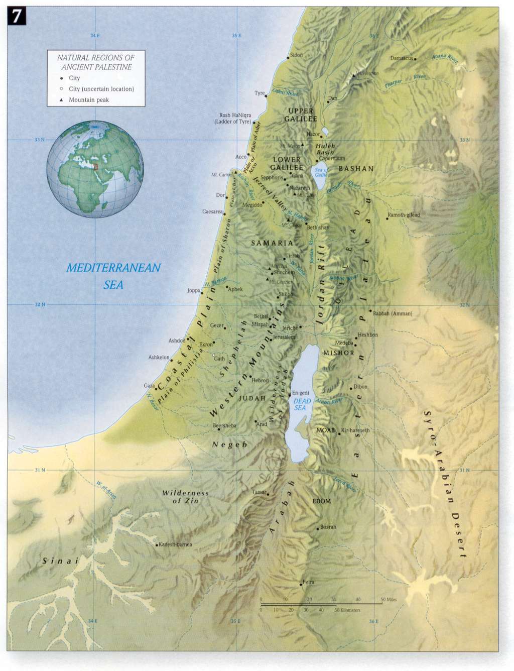 |
| Map showing the topographical regions in Israel |
Comments
Post a Comment