
Chapter 3: Biblical Routes and Their Historical Context
This article focuses on identifying routes using the following principles:
- In the Bible, references to routes—often marked by the Hebrew term derech (way or road) followed by a place name—point to a network of established paths that connected regions, facilitated trade, and enabled the movement of people, armies, and goods.
- A key feature of these ancient transportation networks is their division into subsections: larger routes, like the Via Maris or King’s Highway, were not single, uniform roads but composites of smaller segments, each bearing a local name tied to the territory it traversed. These subsections reflect how ancient peoples navigated and administered their lands, adapting major highways to regional geography and culture.
- Route naming conventions oftentime reflect a distant terminus. A route far from the sea can be called the road to the sea if that’s where it leads to.
- Oftentimes, the Talmud and other Jewish traditional texts can inform us about route usage and identification in ways that are not appreciated by ordinary scholars. We will attempt to explore those ancient sources and use them to identify those relevant routes.
- We will attempt to find an approximate equivalent modern road that follows a similar course.
Biblical References to Key Routes
Following is a list of probable routes mentioned in the Bible:
1. דרך שור, 2. דרך אפרת, 3. דרך ארץ פלשתים, 4. דרך ים סוף, 5. דרך המלך, 6. דרך האתרים, 7. דרך הבשן, 8. דרך הר שעיר, 9. דרך הר האמורי, 10. דרך מבוא השמש, 11. דרך הערבה, 12. דרך מעלה בית-חורון, 13. מעלה אדומים, 14. דרך בית שמש, 15. דרך הר אפרים, 16. דרך הים, 17. דרך חורונים, 18. דרך מדבר אדום.
Route Details
1. דֶּרֶךְ שׁוּר = Derech Shur
Biblical References: Genesis 16:7, Exodus 15:22, 1 Samuel 15:7
Route Type: East-West desert corridor
Function: A key route linking Egypt’s eastern frontier to the Negev, used by the Patriarchs, exiles, and armies. The "road to Shur" is first mentioned in Genesis 16:7, where Hagar encounters an angel near a desert spring while fleeing southward.
Biblical References to Shur
- Exodus 15:22: After crossing the Red Sea, the Israelites enter the מִדְבַּר־שׁוּר (“Desert of Shur”), likely the arid region immediately east of Egypt’s Nile Delta.
- Genesis 16:7: Hagar is found by an angel עַל־דֶּרֶךְ שׁוּר (“on the road to Shur”), fleeing south from Hebron.
- 1 Samuel 15:7: Saul battles Amalekites “from Havilah to Shur,” marking Shur as Egypt’s eastern boundary.
Locating Shur
- Egyptian Context: Shur (שׁוּר, “wall”) corresponds to Egypt’s fortified eastern frontier, known in Egyptian texts as the “Walls of the Ruler” near Tjaru (Tell Hebua, 30.900°N, 32.350°E). This places Shur in the northwestern Sinai, directly east of the Nile Delta.
- Exodus Geography: If the Israelites crossed the Red Sea near the Ballah Lakes (30.900°N, 32.383°E), they would enter Shur’s desert immediately afterward.
Hagar’s Location: Between Kadesh and Bared
The Torah situates the spring between Kadesh and Bared, Targum Onkelos (Genesis 16:7) translates the location as בֵּין רְקֶם לְחַגְרָא (“between Reqem and Chagra”):
- Reqem: Identified by Josephus (Antiquities 4.7.1) with Petra (30.321°N, 35.479°E), the Nabatean capital in Edom.
- Chagra: Interpreted by archaeologist Benjamin Mazar as a compound of Chalutza (חלוצה, 31.100°N, 34.650°E) and Agr (אגר, “border”), referencing the Limes Palestinae—a Roman-era frontier zone. The Limes Palestinae was a later Roman/Byzantine border network. But it’s reasonable to infer that it followed the course of an earlier frontier zone. Onkelos also translates Shur itself as Chagra, this can mean that the Shur desert ends at Chalutza or the general Limes Palestinae.
- Targum Pseudo-Jonathan translates Bared as Chalutza
This places Hagar’s spring in the southern Negev, somewhere near the headwaters of Nahal Besor (31.233°N, 34.467°E), between Chalutza (a Byzantine-Nabatean hub) and the Edomite border. The spring likely corresponds to Ein Avdat (30.817°N, 34.767°E) or Ein Boker (30.850°N, 34.783°E), perennial oases in the Tzin Desert near Har Boker. It follows then, that the road to Shur, near this spring, passes this location.
Proposed Route: From Shur to the Negev
- Egyptian Terminus: Begins at Tjaru (Tell Hebua, 30.900°N, 32.350°E), Egypt’s gateway fortress.
- Sinai Segment: Traverses the northern Sinai’s arid plateau from east to west, relying on wells like Bir el-Abd (30.850°N, 33.000°E) for water.
- Negev Terminus: Enters Israel following Route 211 (31.233°N, 34.467°E) east of Chalutza.
Mapping the Route
- Egypt to Tzin Desert: Follows ancient caravan tracks from Tjaru to the Negev, avoiding the coastal Philistine route (Derech Eretz Pelishtim).
- Hydrology: Survivable only via rare dug wells (Bir el-Abd) or (Bir-el-Gafgafa).
- Modern Approximation: Mirrored by Egypt’s Bir el-Abd Road and Israel’s Route 211, connecting the Sinai border to Beersheba.
- View the interactive map below to see The Way of Shur (Toggle the layers in the left panel).
See also map after #8 Derech Har Seir. The central gray line represents The Way of Shur.
Conclusion
The דֶּרֶךְ שׁוּר was a critical corridor bridging Egypt and Canaan, navigated by Hagar, the Israelites, and Saul’s armies. By anchoring Shur to Egypt’s delta frontier and Hagar’s spring to the southern Negev (between Chalutza and Petra), this framework resolves long standing geographic ambiguities. The route’s legacy endures in the Negev’s arid beauty—a testament to survival and divine providence.
Pin Locations
- Tjaru (30.900°N, 32.350°E)
- Ein Boker (30.850°N, 34.783°E)
- Chalutza (31.100°N, 34.650°E)
- Nahal Besor (31.233°N, 34.467°E)
Alternative View: Gulf of Aqaba
An alternative view emerges if we accept that the exodus sea crossing occurred at the gulf of Aqaba. Midbar Shur is then somewhere near Aqaba in western Arabia. According to this view, Chagra is Hegra in the Hijaz. This also aligns with what some propose to be the location of Havila as being in the Hijaz region of Saudi Arabia or even further towards Yemen.
- Nuweibaa Beach: 29°2′N, 34°40′E
- Midbar Shur (near Aqaba): 28.5000°N, 36.0000°E
- Chagra (Hegra/Mada'in Saleh): 26.6170°N, 37.9500°E
- Havila (Hijaz region of Saudi Arabia): 24.0000°N, 40.0000°E
- Havila (further towards Yemen): 18.0000°N, 45.0000°E
2. בְּדֶרֶךְ אֶפְרָת = Derech Efrat
- Biblical Term: בְּדֶרֶךְ אֶפְרָת (Genesis 35:19, 48:7)
- Biblical Context: Genesis 35:19 – “So Rachel died and was buried on the way to Ephrath (that is, Bethlehem).” Genesis 48:7 – Jacob recalls this same route: “I buried her there on the way to Ephrath.”
- Route Type: North–South, highland ridge route subsection
- Function: The segment of the Way of the Patriarchs that leads from Jerusalem southward toward Bethlehem, associated with the journey of Jacob as he buried Rachel.
- Geography: Follows the central ridge just south of Jerusalem; Passes through the region historically called Efrat (Ephrath); Continues toward Bethlehem, where Rachel was buried.
- Modern Equivalent: Highway 60, particularly the Jerusalem–Bethlehem segment, running through modern Gilo and near the modern town of Efrat.
3. דרך ארץ פלשתים = Derech Eretz Pelishtim
Explanation: Derech Eretz Pelishtim, meaning "the Way of the Land of the Philistines," is identified in Exodus 13:17 as the route the Israelites avoided during the Exodus: “When Pharaoh let the people go, God did not lead them on the road through the Philistine country [Derech Eretz Pelishtim], though that was shorter. For God said, ‘If they face war, they might change their minds and return to Egypt.’” This route corresponds to the southern section of Via Maris, known to the Egyptians as the Way of Horus, a major military and trade route from Egypt to Canaan. It began at the Egyptian fortress of Tjaru (Sile, near modern Qantara, 31.016°N, 32.383°E), crossed the northern Sinai Peninsula, and reached Wadi el-Arish/Rafah (31.288°N, 34.251°E), marking the entry into Philistine territory at the border of the Gaza Strip. Spanning approximately 150 kilometers (93 miles), this path was the shortest route from Egypt to Canaan but was avoided due to the risk of conflict with the Philistines. The route aligns with the historical Way of Horus, approximated today by modern Route 40 through the northern Sinai. While the Way of Horus is part of the broader Via Maris network, discussed later, this entry focuses on its southern section at the threshold of Philistine territory, as referenced in the Torah.
4. דֶּרֶךְ יַם-סוּף = Derech Yam Suf
Context of the Detour: This is mentioned in 2 different contexts, first after the episode with the spies, they head toward Derech Yam Suf and circle around for nearly 40 years. The second time is after Edom blocks Israel’s request to traverse the King’s Highway (Numbers 20:17–21), the Israelites retreat southward “by the way of Yam Suf” (Numbers 21:4), then turn east and north to circumvent Edom.
Questions: This maneuver raises two key questions: 1. What is the geographic referent of Yam Suf? 2. Does the term דֶּרֶךְ יַם־סוּף (Derech Yam Suf) in Numbers 21:4 and Deuteronomy 1:40 denote a named route (like the King’s Highway) or simply a southerly direction toward the Red Sea?
Yam Suf Exploration: To attempt to identify the definition would require us to explore the location of the Yam Suf crossing during the exodus some 40 years earlier. We have 3 commonly known opinions on the location of the crossing. 1. The gulf of suez, fairly close to the Nile delta where the Israelites left Egypt. 2. A theory popularized by Ron Wyatt, that the crossing happened far to the east, at the gulf of aqaba. That would place Sinai in Saudi Arabia's Jabal Al Lawz region. 3. The academic opinion, that the crossing was at the marshes of Lake Timsah in the Nile Delta.
Analysis: The simplest reading of a southerly detour from Edom towards Yam Suf would seem to support Ron Wyatt's identification of a gulf of Aqaba Yam Suf. Such a route would follow the Arabah south, either near modern route 90, or further east on the southern portion of the king's road toward the gulf of Aqaba or perhaps it wasn’t a defined route at all, only a direction. How can we reconcile this southern route from Edom with the other definitions of Yam Suf? We can propose two solutions. One solution will reconcile the identification of Yam Suf with the Gulf of Suez, the other will reconcile it with the Lake Timsah/Nile Delta.
- Much like today, we identify the entire body of water including the 2 gulfs, as the red sea, the bible too calls them both Yam Suf. The crossing happened at the portion of Yam Suf known as the Gulf of Suez, and the southern detour from Edom went towards the portion of Yam Suf known as Gulf of Aqaba! This route could be the same as the one mentioned above, either the Arabah route, equivalent to modern route 90, or the southern portions of the King's road or perhaps only a direction and not a route.
- This would positively identify Derech Yam Suf as a specific road. It is known that the ancient Egyptians had a wilderness route starting from the Nile Delta and through the sinai desert towards the King's road. This route was used for their turquoise and copper mining operations. From the perspective of someone near Transjordan, this road would lead towards the Nile Delta and Lake Timsah. We can then propose that the Israelites went south towards the Trans-Sinai road that terminated in the Reed Sea/Lake Timsah area. Just like Derech Eretz Pelishtim and Derech Hayam and Derech beth shemesh were named after their terminus, so too this route was named after its terminus.
Additional Considerations: The location of Horeb/Sinai is purported to be near Mt Seir. The identification of both of them is unclear. There is some evidence of Edom extending much further south, all the way to the gulf of Aqaba. This would be supported somewhat by the biblical narrative. Moses says that they were in the Arabah, near Eilat and Ezion Geber, but they needed to head towards the Yam Suf to circumvent Edom. That would indicate a much more southern Edomite influence, and a much deeper southern detour, deep into the eastern flank of the gulf of Aqaba, towards the Saudi Arabian territory. Perhaps that is the meaning of Derech Yam Suf.
Pin Locations: Gulf of Aqaba (29.532°N, 34.950°E), Aqaba (29.532°N, 35.006°E), Negev (30.500°N, 34.750°E).
5. דֶּרֶךְ הַמֶּלֶךְ = Derech HaMelech (King’s Highway)
- Explanation: The main north-south trade route through Transjordan, east of the Jordan River, running from Aqaba, through the highlands of Edom, Moab, and Ammon, all the way to Damascus and beyond, to Mesopotamia. This route hugs the eastern edge of the Transjordanian Plateau. The Israelites requested passage from Edom during their Exodus journey but were denied (Numbers 20:17). Today, this route is followed by Jordan’s Highway 35 through the central highlands, from Irbid to Ma’an via Madaba, Karak, and Petra, merging with Highway 15. The parallel Jordan Valley route (Route 65) follows the lower Bik’a (Jordan Valley) along the Dead Sea, connecting to the King’s Highway via east-west routes like Ma’ale Adumim.
- Pin Locations: Irbid (32.556°N, 35.850°E), Ma’an (30.196°N, 35.734°E), Madaba (31.716°N, 35.794°E), Karak (31.181°N, 35.704°E), Petra (30.321°N, 35.479°E), Dead Sea (31.000°N, 35.500°E).
6. דֶּרֶךְ הָאֲתָרִים = Derech Ha'atharim
- Explanation: This route, meaning “Way of the Atharim,” was used by the Canaanite king of Arad to attack the Israelites in the Negev (Numbers 21:1). Nearly all the classic commentaries interpret this not as a named route, but as “the route of the spies”. If the spies set out from Kadesh Barnea, they would ascend in the negev, then this would probably equate to modern route 40 and lead to Highway 60 towards Shechem in the central highlands. The Talmud and Midrash explain that Caleb stopped at Hebron on the way to pray at the Cave of the Patriarchs. However, Rashi quotes the Sages that the spies traveled east-west and north-south, like an ‘L’ shape. This complicates the precise route taken. After traversing the land, the spies returned to the desert and were followed clandestinely by the King of Arad. The Talmud relates that these were really Amalekites who disguised themselves as Canaanites to avoid suspicion.
- Pin Locations: Arad (31.252°N, 35.214°E), Shechem (32.221°N, 35.255°E)
7. דֶּרֶךְ בָּשָׁן = Derech Bashan
- Explanation: A northern subsection of the King’s Highway through Bashan in Transjordan, used by the Israelites to approach Og, king of Bashan, at Edrei (Numbers 21:33). Bashan is in the modern Golan Heights and northern Jordan, east of the Jordan River. This segment is followed by Jordan’s Highway 35, which runs through the Transjordanian highlands from Amman to Irbid, near the Golan Heights.
- Pin Locations: Edrei (32.621°N, 36.102°E), Amman (31.953°N, 35.934°E), Irbid (32.556°N, 35.850°E), Golan Heights (33.000°N, 35.750°E).
8. דֶּרֶךְ הַר-שֵׂעִיר = Derech Har Se'ir
Explanation: A route from Horeb/Sinai, taken before the sin of the spies that went to Kadesh Barnea via Derech Har Seir.
Opening question: If Sinai was in Jabal-Al Lawz which is in the Arabian Peninsula, ala Ron Wyatt, then it would be logical to travel to Kadesh Barnea in the Negev via the ‘road to seir’. But if we accept the more traditional identification of Sinai as being in the Sinai Peninsula, which is already west of Seir, why would one travel to Kadesh Barnea via Derech Har Seir?
Resolution: A topographic analysis of the Sinai desert around the traditional location of Horeb reveals a mountainous and difficult terrain. This is marked by steep ascents and narrow wadis, unsuitable for quick travel, especially for a large crowd with children and animals. A direct linear route may be shorter in distance but longer in time and effort. Travelling on a longer, flatter and wider path would be advantageous. If one travels further south and east of Horeb and stays on the western coast of the gulf of Aqaba, they would find such a wide and flat plain. Biblical route names often derive from termini (start/end points) or regions traversed. Derech Har Se'ir (“Way of Mount Seir”) likely refers to a route oriented toward Edomite territory (Mount Seir), even if it did not pass directly through it. This route is mentioned as part of the Israelites’ 11-day journey from Horeb to Kadesh-Barnea (Deuteronomy 1:2), prior to the 40-year wilderness wandering. This also seems to be Rashi’s view.
Proposed Route
- Starting Point: If Horeb/Sinai is located in southeastern Sinai (e.g., Jebel Musa, 28.556°N, 33.976°E), the following path is longer in distance but avoids the peninsula’s mountainous interior and follows the mostly flat and wide coastal area.
- Coastal Segment: Follow the Dahab-Taba road north along the Gulf of Aqaba’s western coast. This flat, fast corridor passes key oases like Dahab (28.509°N, 34.513°E) and Taba (29.492°N, 34.902°E).
- Junction at Aqaba/Eilat: At the Gulf’s northern tip (Aqaba/Eilat, 29.532°N, 34.950°E), the route connects to the King’s Highway—Transjordan’s primary north-south artery.
- Turn Northwest: Instead of continuing north on the King’s Highway, the Israelites would veer west into the Arabah Valley (modern Route 90), then northwest toward Kadesh-Barnea (Tell el-Qudeirat, 30.687°N, 34.496°E).
Naming Logic
Directional Reference: The route arcs toward Edom’s southern border (near Aqaba), justifying the name Derech Har Se'ir.
Challenges
Horeb’s Uncertain Location:
- Traditional View: Jebel Musa (Sinai Peninsula).
- Alternate Theories: Jabal al-Lawz (NW Saudi Arabia) 28.651°N, 35.316°E or central Negev 30.283°N, 34.750°E.
- Impact: Relocating Horeb drastically alters the route’s trajectory.
Pin Locations
- St. Catherine’s: 28.556°N, 33.976°E
- Dahab: 28.509°N, 34.513°E
- Taba: 29.492°N, 34.902°E
- Kadesh-Barnea: 30.687°N, 34.496°E
The map below illustrates biblical routes, including a gray line for The Way of Shur.
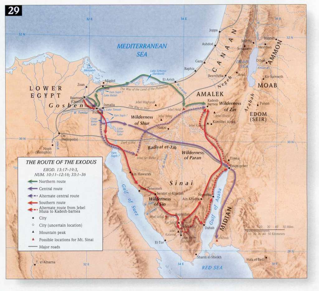
Illustration of biblical routes in the region.
9) Deuteronomy 1:19 (MT): “דֶּרֶךְ הַר הָאֱמֹרִי” = Derech Har Ha'emori
Explanation: Ramban and Midrash clearly explain this to mean the road that traverses Edom, Moab and Ammon toward the Amorite hill country in Transjordan, taken by the Israelites during their approach to the Promised Land (Deuteronomy 1:19). The “Amorite hill” likely refers to the highlands north of Edom, in Moab and Ammon, which were conquered by Sihon the Amorite (Numbers 21:21–26). This route is part of the King’s Highway through the plateau north of Edom and Moab, leading to Sihon’s lands in Transjordan. Today, it is likely connected to the King’s Highway (Highway 35) in Transjordan.
Pin Locations: Kadesh-Barnea (30.687°N, 34.496°E), Amman (31.953°N, 35.934°E), Karak (31.181°N, 35.704°E).
We have identified and mapped 9 routes. In the next part of the series, we will continue with the remaining 9 routes.
Back to Ancient Trade Routes - Part I Biblical Routes - Part III
Comments
Post a Comment